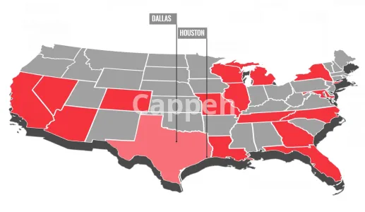
Introducing clickable interactive map creation services
As a professional cartographer, I have specialized in creating interactive maps, customized data visualizations, and graphic mapping solutions for web applications and diverse platforms over the past few years.
My services include:
Crafting bespoke designs for your maps, accommodating a variety of elements such as polygons (including countries, states, zip codes, delivery zones, etc.), polylines (like roads, routes, hiking trails, etc.), and points (such as markers with icons, buildings, specific addresses, etc.), as well as maps integrating a mix of these components.
Implementing interactive features for your maps, including clickable hyperlinks, pop-ups, animations, and different click and hover interactions.
Integrating data with the map. Whether it's text, images, videos, or links, the data can be embedded directly into the map's code or stored in external resources.
The tools I utilize for creating interactive maps include:
Technologies such as HTML5, CSS, and SVG graphics.
Software tools like D3.js, Google Maps, Leaflet.js, Mapbox, React, OSM, Power BI, and Tableau.
GIS platforms and tools including ArcGIS, QGIS, Google Earth, Illustrator, among others.
My commitment:
I will assist you in determining the most suitable type of interactive map for your needs, organizing your data efficiently, and ensuring seamless map installation.
| Shop Location | Pakistan |
No reviews found!






No comments found for this product. Be the first to comment!